


10,5 km | 12,5 km-effort
![Randonnée A pied Weimar (Lahn) - [W8] Ortsrundweg Roth - Wolfshausen - Argenstein - Roth-Landsynagoge - Photo](https://media.geolcdn.com/t/1900/400/a1b86607-88a4-4848-8acb-0b8e51303bdb.jpeg&format=pjpeg&maxdim=2)

Tous les sentiers balisés d’Europe GUIDE+


Application GPS de randonnée GRATUITE
 SityTrail
IGN / Instituts géographiques
SityTrail World
Le monde est à vous
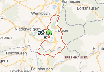
Randonnée A pied de 11,9 km à découvrir à Hesse, Landkreis Marburg-Biedenkopf, Weimar (Lahn). Cette randonnée est proposée par SityTrail - itinéraires balisés pédestres.
Randonnée créée par Gemeinde Weimar (Lahn).
Symbole: Gelber Text "W8" auf schwarzem Hintergrund
![Randonnée A pied Weimar (Lahn) - [W8] Ortsrundweg Roth - Wolfshausen - Argenstein - Roth-Landsynagoge - Photo 1](https://media.geolcdn.com/t/2048/auto/9e3f6965-1752-4e4f-8d4d-6cc4321a62c6.jpeg&format=jpg&maxdim=0 "Randonnée A pied Weimar (Lahn) - [W8] Ortsrundweg Roth - Wolfshausen - Argenstein - Roth-Landsynagoge - Photo 1")
![Randonnée A pied Weimar (Lahn) - [W8] Ortsrundweg Roth - Wolfshausen - Argenstein - Roth-Landsynagoge - Photo 2](https://media.geolcdn.com/t/2048/auto/40ff3de6-fc07-4fd3-8676-5e47668b1ac1.jpeg&format=jpg&maxdim=0 "Randonnée A pied Weimar (Lahn) - [W8] Ortsrundweg Roth - Wolfshausen - Argenstein - Roth-Landsynagoge - Photo 2")
![Randonnée A pied Weimar (Lahn) - [W8] Ortsrundweg Roth - Wolfshausen - Argenstein - Roth-Landsynagoge - Photo 3](https://media.geolcdn.com/t/2048/auto/5f2dc50a-0705-4e27-91df-e77bfd6230c7.jpeg&format=jpg&maxdim=0 "Randonnée A pied Weimar (Lahn) - [W8] Ortsrundweg Roth - Wolfshausen - Argenstein - Roth-Landsynagoge - Photo 3")
![Randonnée A pied Weimar (Lahn) - [W8] Ortsrundweg Roth - Wolfshausen - Argenstein - Roth-Landsynagoge - Photo 4](https://media.geolcdn.com/t/2048/auto/2498ab6c-c621-4572-9f98-0efb4eef1d89.jpeg&format=jpg&maxdim=0 "Randonnée A pied Weimar (Lahn) - [W8] Ortsrundweg Roth - Wolfshausen - Argenstein - Roth-Landsynagoge - Photo 4")
![Randonnée A pied Weimar (Lahn) - [W8] Ortsrundweg Roth - Wolfshausen - Argenstein - Roth-Landsynagoge - Photo 5](https://media.geolcdn.com/t/2048/auto/0d6b3fe3-931f-4390-a4e2-965e2b3de628.jpeg&format=jpg&maxdim=0 "Randonnée A pied Weimar (Lahn) - [W8] Ortsrundweg Roth - Wolfshausen - Argenstein - Roth-Landsynagoge - Photo 5")
![Randonnée A pied Weimar (Lahn) - [W8] Ortsrundweg Roth - Wolfshausen - Argenstein - Roth-Landsynagoge - Photo 6](https://media.geolcdn.com/t/2048/auto/a64498d6-3715-459a-9821-a44e0705b5c3.jpeg&format=jpg&maxdim=0 "Randonnée A pied Weimar (Lahn) - [W8] Ortsrundweg Roth - Wolfshausen - Argenstein - Roth-Landsynagoge - Photo 6")
![Randonnée A pied Weimar (Lahn) - [W8] Ortsrundweg Roth - Wolfshausen - Argenstein - Roth-Landsynagoge - Photo 7](https://media.geolcdn.com/t/2048/auto/f38803f0-db6c-43b3-9fd8-c2e5cd691750.jpeg&format=jpg&maxdim=0 "Randonnée A pied Weimar (Lahn) - [W8] Ortsrundweg Roth - Wolfshausen - Argenstein - Roth-Landsynagoge - Photo 7")
![Randonnée A pied Weimar (Lahn) - [W8] Ortsrundweg Roth - Wolfshausen - Argenstein - Roth-Landsynagoge - Photo 8](https://media.geolcdn.com/t/2048/auto/d202d462-608a-4d6b-9f2d-822d7555b541.jpeg&format=jpg&maxdim=0 "Randonnée A pied Weimar (Lahn) - [W8] Ortsrundweg Roth - Wolfshausen - Argenstein - Roth-Landsynagoge - Photo 8")
![Randonnée A pied Weimar (Lahn) - [W8] Ortsrundweg Roth - Wolfshausen - Argenstein - Roth-Landsynagoge - Photo 9](https://media.geolcdn.com/t/2048/auto/a1b86607-88a4-4848-8acb-0b8e51303bdb.jpeg&format=jpg&maxdim=0 "Randonnée A pied Weimar (Lahn) - [W8] Ortsrundweg Roth - Wolfshausen - Argenstein - Roth-Landsynagoge - Photo 9")
![Randonnée A pied Weimar (Lahn) - [W8] Ortsrundweg Roth - Wolfshausen - Argenstein - Roth-Landsynagoge - Photo 10](https://media.geolcdn.com/t/2048/auto/be93cee4-faab-466d-b9f8-ef943bb50d5d.jpeg&format=jpg&maxdim=0 "Randonnée A pied Weimar (Lahn) - [W8] Ortsrundweg Roth - Wolfshausen - Argenstein - Roth-Landsynagoge - Photo 10")
A pied
![Randonnée A pied Weimar (Lahn) - [W8-Alternative] Ortsrundweg Roth - Wolfshausen - Argenstein - Roth - Photo](https://media.geolcdn.com/t/375/260/a1b86607-88a4-4848-8acb-0b8e51303bdb.jpeg&format=jpg&maxdim=2)
A pied
![Randonnée A pied Weimar (Lahn) - [W7] Ortsrundweg Niederwalgern - Kehna - Stedebach - Niederwalgern - Photo](https://media.geolcdn.com/t/375/260/2a98fd64-b158-468b-bf37-6a7c1e3c189d.jpeg&format=jpg&maxdim=2)
A pied
![Randonnée A pied Weimar (Lahn) - [W3] Ortsrundweg Oberweimar - Allna - Oberweimar - Photo](https://media.geolcdn.com/t/375/260/f5153156-6f06-4603-b3b8-7256b8f991b7.jpeg&format=jpg&maxdim=2)
A pied
![Randonnée A pied Weimar (Lahn) - [W6] Ortsrundweg Niederweimar - Oberweimar - Niederweimar - Photo](https://media.geolcdn.com/t/375/260/3bc795d5-8ccb-48ab-b7f6-fe7f27730326.jpeg&format=jpg&maxdim=2)
A pied
![Randonnée A pied Weimar (Lahn) - [W2] Ortsrundweg Oberweimar - Wenkbach - Oberweimar - Photo](https://media.geolcdn.com/t/375/260/6da0cae2-72c4-47db-9d8f-f58978ab8205.jpeg&format=jpg&maxdim=2)
A pied

Vélo